In the last issue we went into some detail on how thunderstorms develop, and how they can go from your average summer day thunderstorm to a severe thunderstorm.
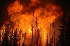
Thunderstorms can bring a wide variety of severe weather with them: heavy rains, hail, high winds, lightning, and, on some occasions, tornadoes.
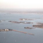
After an extended period of dry weather across large portions of southern and central Alberta, an upper-level low brought significant rains to almost all areas. This leads nicely into this issue’s topic of severe summer weather and heavy rainfall.
Read Also
Weather whiplash: Alberta saw best and worst of winter this year
Prairie precipitation fell short of average this winter everywhere but Calgary, raising questions heading into seeding.
While we do not necessarily need thunderstorms to bring heavy rain, generally, most of our really big rainfalls are associated with them. As you probably already know, warm air can hold a lot more moisture than cold air. At -20 C, the air can hold about 1.0 gram of water for every cubic metre. At 0 C, that increases to around 5.0 grams, at 20 C it is around 17 grams, and it jumps all the way up to 30 grams per cubic metre at 30 C.
This would mean that a storm system forming on a hot summer day may have up to six times as much water to work with as one that formed at near-zero temperatures.
We also have to remember that the atmosphere is vertical, with heights during the thunderstorm season typically reaching 10,000 metres.
While the amount of moisture within this column of air is not vertically uniform, we can still make some back-of-the-envelope calculations to get an idea of just how much water can be available in the atmosphere to form rain.
Let’s say that in a really moist atmosphere about one-quarter of a one metre by one metre by 10,000-metre column of air is close to having 100 per cent humidity, and that the average air temperature of this part of the column is about 20 C. That would mean that each cubic metre of air would have about 17 grams of water, but let’s say 15 grams just to make the math a little easier.
So the column of air would have around 10,000 x one-quarter x 15 grams of water or 37,500 grams. One gram of water is roughly equivalent to one cubic centimetre (cm3). So this column of air would have about 37,500 cm3 of water or 37.5 litres.
If all this moisture could fall out of the column of air that would equal about 37.5 millimetres of rainfall.
Now these calculations are just hypothetical, but it gives you a bit of an idea as to just how much water can be in the atmosphere above our heads.
Meteorologists calculate this figure, and it is referred to as precipitable water or PWAT. The amount of PWAT varies greatly from place to place, time of year, and type of air mass that is in place. Take the storm system that brought all the rain in the middle of June — the moisture in the atmosphere was thick, with a good part of the atmosphere being close to saturated. This resulted in PWAT values that were in the 30- to 40-millimetre range.
So these warm-season storms can have a lot of water to work with. Yet if a thunderstorm was just dealing with the amount of water in the air within the thunderstorm itself, then we would not actually see any huge rainfalls.
If all the water in a column of air was condensed out, the most precipitation we would typically see in our region is about 50 millimetres. So how can we get storms that dump more than this, sometimes as much as 100 to even 250 millimetres? The answer is — the horizontal movement of air.
If you watch the flow of air across our planet you will see how storm systems can tap into huge flows of air that can literally cover thousands of square kilometres. This means that as a storm is condensing out the moisture available for rainfall, new moisture is moving in to replace that moisture, allowing rainfall amounts to really ramp up.
In thunderstorms, the movement of the storm and its short life cycle will put a limit on just how much rain can fall. But sometimes thunderstorms will stall over a region, allowing for some truly extreme rainfall events.
At other times, we can get something called thunderstorm training. This is when a series of thunderstorms form in the same general area and follow each other, one after another, bringing several rounds of heavy rainfall.
Just what is considered heavy rainfall across our region?
According to Environment Canada, a short-duration summer rainfall warning will be issued if 50 millimetres of rain or more is expected within a one-hour period — usually caused by thunderstorms. Whereas a long-duration rainfall warning will be issued if 50 millimetres or more is expected to fall within a 24-hour period or if 75 millimetres or more is expected to fall within 48 hours. This is usually the result of a slow-moving area of low pressure, though this could also be related to several rounds of heavy thunderstorms.
We will continue our look at severe summer weather by looking at high winds and hail in the next few issues.