In the last issue we discussed warm and cold clouds and we learned that most of our local precipitation is produced in cold clouds, which means that most of it starts off as snow — even in the summer.
This week we are going to look at the different types of precipitation we experience and examine how each type forms. Before we investigate this topic, there are a couple of weather- or weather-related stories in the news over the last week or so that I would like to touch on.
The first is a story about the summer forecast across our region and how there is no strong controlling factor like an El Niño or La Niña currently in place. The story reports that due to this lack of a major weather influence, this summer’s forecast will be tougher than usual to figure out. While I partly agree with this, the impact of both El Niño and La Niña weather patterns in the summer are never as strong as their winter impacts. We will take some time in the next issue to look into this a bit more.
Read Also

How Earth evens out the energy input
Earth has surpluses of radiation in its equatorial regions, and deficits toward its poles. Our weather is a matter of Earth trying to even out the imbalance, Daniel Bezte writes.
The second story was about coral bleaching. If ocean water temperatures get too warm around coral, the coral expels its symbiotic algae which lives within it the coral and is what gives the coral its colour. This loss of the symbiotic algae makes the coral appear white like it has been bleached, thus the term coral bleaching.
While this does not necessarily kill the coral, it does weaken it and makes it more vulnerable to disease and over time the stress can make it die. According to NOAA and the International Coral Reef Initiative, since 2023 more than 80 per cent of the Earth’s coral has been bleached. If you don’t believe our planet is warming, I am not sure what more evidence you need — beside the record heatwaves, retreating glaciers and declining polar sea ice.
Now let’s look at different types of precipitation. We now know that most of the rain that falls in our region begins as snow within the cloud. As the snow begins to fall it encounters warmer and warmer air. This leads to the snow melting and turning into rain.
One thing that you may have noticed is that often when it first begins to rain, the drops are very large, then as it continues raining the drops become smaller. There are two reasons why this happens.
Initially, both large and small droplets begin falling from the cloud, but because the large droplets have more mass their terminal velocity is higher — that is, they fall faster than the small droplets. Therefore, the large droplets reach the ground before the smaller droplets.
Secondly, if you recall, the air beneath a cloud is usually not completely saturated with moisture, so when the rain starts to fall the droplets begin to evaporate. The smallest of the droplets will totally evaporate while the larger ones will make it to the ground.
When thinking about precipitation, since most precipitation begins as snow, it makes perfect sense that we see snow falling when it is cold outside. However, snow can fall even when it is above freezing as the warm layer of air near the surface is often not deep enough to give the snow time to melt on the way down.
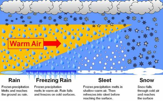
Next on our list of precipitation types is sleet or ice pellets. This form of precipitation is created when raindrops freeze in the air before they reach the ground. This type of precipitation does not occur that often, and when it does, it can sometimes be mistaken for small hail (remember, hail forms in thunderstorms). Sleet begins as snow and then melts into rain as it encounters warm air. Usually, once a snowflake melts into rain, the air below the cloud will remains warm and we will only see rain, but sometimes there is a lower layer of air that is below the freezing point. Once the raindrop encounters this layer, if it is deep enough, the raindrop will freeze and hit the ground as a transparent or semi-transparent ice pellet. These pellets are usually less than 5 millimetres in diameter.
If the same process occurs, but the low layer of cold air is not deep enough, the falling raindrop will not have enough time to freeze. As the drops fall through the layer of freezing air they become super cooled (water that is below zero but still a liquid). When the drops hit the surface they form a thin film of water that freezes very quickly. This is what creates that smooth continuous coating of ice that creates really nasty driving conditions. This is another way that freezing rain can form (we examined the other way in last week’s article).
The next two types of precipitation are graupel (snow pellets) and hail. Both types of precipitation form in similar ways but need much different conditions for us to see them fall to the ground. These forms of precipitation begin their lives as a snowflake or ice crystal that grow by the process of riming (layers of ice forming around the ice crystal). These snow pellets then fall to the ground as hard white little balls that kind of look like miniature hailstones (graupel). Since the centre of the pellet has a large amount of air in it, the pellets are fairly light and rarely reach velocities greater than 10 kilometres an hour.
Under the right conditions (thunderstorms) the graupel can undergo a series of trips within the storm where it is carried upwards into a freezing region of the cloud and then back again into a warm region. Each time it gains a layer of water in the warm region and then that layer freezes in the cold region. In very strong thunderstorms, hailstones can grow to 3 centimetres or more in diameter, which can give you a final velocity of over 110 kilometres an hour.