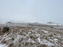
Overall, the weather model got the general big picture correct during the last forecast period, it was a just a little off on the finer details. We saw a large area of low-pressure impact southern Saskatchewan and Manitoba as predicted, which brought some significant amounts of rain and even a few flakes of wet snow.
The second area of low pressure developed as forecasted but it stayed further south than expected. A trough of low pressure extended to the northwest and brought clouds and showers to much of Southern Saskatchewan and western Manitoba to end the long weekend.
Read Also
Prairie forecast: Arctic air dominates the forecast
For this forecast period, it appears we will need to wait a little longer for spring to arrive. Weather models continue to show a northwesterly flow across the region, but this time the dividing line between mild and cold air has shifted slightly farther south. As a result, near to below-average temperatures are expected across much of the Prairies.
Over Alberta, central and northern regions saw the expected average May weather over the long weekend, while regions to the south were cooler with showers.
Overview
For this forecast period, it seems set to dry out and warm up. I suppose that’s good for the areas that recently received significant rainfall and not so good for those regions dealing with fires.
Currently there is a large area of low pressure south of the Great Lakes with a trough of low-pressure stretching northwestwards to an area of low pressure over the Yukon. This trough will bring plenty of clouds across the Prairies on Wednesday. A good portion of Alberta and Saskatchewan should see showers while Manitoba just deals with clouds.
This trough will start to break down on Thursday as weak upper-level ridging tries to build across the western Prairies. Further east, Arctic high pressure will settle into Northwestern Ontario. This high will help clear out the eastern Prairies. While the air associated with the high will start out on the cool side, the coldest air will be well to the east of the Prairies and the strong, late spring sun will quickly warm the air mass.
The upper ridge and east high should bring a prolonged sunny period accompanied by generally light winds. Temperatures will start off in the upper teens and will warm into the mid-twenties by late in the weekend. They may move into the upper twenties or low thirties by the early part of next week.
Alberta
This forecast period will start off cloudy with showers as a trough of low pressure works its way through the province. By Thursday the trough will weaken and lift off to the east. This will bring clear skies.
An upper ridge of high pressure will begin building in, which will help to boost temperatures back into the low twenties by the weekend. Some of the weather models show some instability sticking around on Thursday and Friday. This could trigger some afternoon showers or thundershowers.
Over the weekend, skies look to clear as the upper ridge continues to build. Expect sunny skies through the weekend and into at least the first half of next week. Along with the sunny skies will come warm, summery temperatures. Expect daytime highs in the mid-twenties by late in the weekend and in the upper twenties to low thirties for most of next week.
Saskatchewan and Manitoba
One more day of clouds across these provinces as the upper trough of low pressure finally weakens and breaks up. Saskatchewan looks to see a few more showers on Wednesday while Manitoba looks to miss any more rain. Temperatures will be mildest over Manitoba due to thinner cloud cover and no precipitation.
The weather models then show an area of high pressure settling into northern or northwestern Ontario. While the core of this high will be on the cool side, it should be far enough away that we should not get too cold. In fact, the clockwise rotation around the high will help draw mild air to the west thanks to a building upper ridge over that region.
The building upper ridge to our west, combined with the large area of high pressure to our east, should result in sunny skies through the weekend and into next week. Along with the sunny skies, winds look to be relatively light for most of this forecast period which is good news for regions fighting fires.
What isn’t good news is that there looks to be little to no precipitation, and we will see temperatures warming towards the mid-twenties by late in the weekend. We could see mid to upper twenties by the middle of next week.