Another month has come and gone, and depending on where you live it was either a near-average April or you were cold and wet.
Listening to the general talk about April’s weather, you would probably come to the conclusion that most areas across the Prairies had a miserable month. But in reality, most places experienced average April weather. I think the main reason for this line of thinking was the warm start to the month. This kind of set a benchmark in people’s minds and when the second half of the month was cooler it made it seem like the whole month was just plain cold.
Read Also
Weather whiplash: Alberta saw best and worst of winter this year
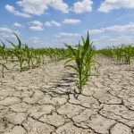
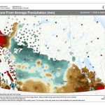
Prairie precipitation fell short of average this winter everywhere but Calgary, raising questions heading into seeding.
If one area of the Prairies had the right to complain about April’s weather it would be Alberta. The month started off nice with plenty of warm early-April temperatures. Edmonton, for example, saw daytime highs in the low to mid-teens on four of the first seven days of the month.
Unfortunately, after that first week, cool, unsettled weather moved in and the region ended up only seeing two more days with daytime highs in the teens for the rest of the month. When all of the numbers were added up, it turns out that the Edmonton region was the coldest part of Alberta in April compared to average, coming in 2.0 C below the long-term average.
To the north, temperatures in the Peace River region were also colder than average with a mean monthly temperature that was about 1.5 C below average. Travelling to the south, Calgary fared a little better, with a mean monthly temperature that was just slightly below average.
Along with the cold temperatures came plenty of precipitation across nearly all of Alberta. Both Edmonton and Calgary reported nearly double the average amount of precipitation, with about 55 millimetres falling in both locations. The Peace River region was a little above average, with 25 millimetres reported. What was probably most annoying about all of the precipitation was that it didn’t fall in just one or two big events, but was spread out over several events. Both Edmonton and Calgary reported measurable precipitation on 50 per cent of the days in April.
Moving eastward into Saskatchewan we find conditions warming up a little bit and drying out. This region saw the same warm start and cool end to the month, but when it was all averaged out, Saskatoon ended up reporting near-average temperatures while Regina was slightly below average. Precipitation in both of these centres was also slightly below average. The only wet areas in Saskatchewan were the regions along the border with Alberta.
Moving into Manitoba, we see a bit of a mixed bag. Over western regions temperatures in both Brandon and Dauphin were right around average for April. Farther east, in Winnipeg, April was a touch warmer, with a mean monthly temperature that was just slightly above average. Precipitation was below to well-below average in western regions and was right on average in the Winnipeg region. Manitoba’s Interlake was the wet spot, where amounts were nearly double the long-term average.
Overall, it was cold and wet across Alberta, with near-average temperatures and dry conditions across most of Saskatchewan and western Manitoba, and near-average and wet conditions across north-central and eastern agricultural regions.
Now the fun part: Whose forecast was closest and what does our May and June outlook hold?
Not sure who to give the nod to this time around. The Old Farmer’s Almanac called for near- to slightly below-average temperatures and near-average amounts of precipitation. So it was close for Manitoba and Saskatchewan, but missed out on Alberta. My forecast was lacking in detail, but did discuss that it looked like it was going to start off mild with a switch to cooler and wetter conditions during the second half of the month. I think I should give the nod to the Old Farmer’s Almanac.
Now on to May-June’s forecast.
According to Environment Canada, most of the Prairies will see near-average temperatures and precipitation. The Old Farmer’s Almanac is calling for a warm and dry May followed by a little cooler and very wet June. The Canadian Farmers’ Almanac seems to be calling for a cool and wet May as it mentions storms and wet conditions several times. As for temperatures, it mentions either pleasant or chilly weather a couple of times. Its June forecast looks to be calling for wetter-than-average conditions, with the mention of thunderstorms and severe weather several times. Temperatures look to be near average to begin the month, then turning very warm near the end of the month.
Lastly, my forecast. Our current medium-range forecast points towards above-average temperatures and near- to below-average precipitation during the first half of May. There is then a hint that we will transition back towards a cooler and unsettled pattern during the second half of the month. I think we will continue to see this trend going into June, with above-average temperatures and dry conditions dominating for most of the month, with cool and unsettled weather setting back in near the end of June.
Personally, I hope everyone gets the exact type of weather they need to get a successful start to the growing season.