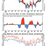
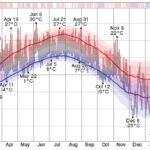
This time I thought I'd take a break from precipitation maps. These temperature graphs for Red Deer (chosen because it is the most central location in Alberta) show the daily maximum and minimum temperatures along with the departure from average for the last 365 days (ending on May 13). Looking at the pattern in the centre graph, it will be interesting to see what the next month might hold in store for Alberta. Will we continue to see a shorter and less pronounced warm spell? Or will we see a rebound since the last below-average period was less intense than the previous ones?

Cooking up thunderstorms with Mother Nature

Severe thunderstorms are a fascinating phenomena and you need 
the right conditions to come together
Reading Time: 4 minutes Thunderstorm season isn’t too far off so we’ll continue our annual look at what is arguably one of the most fascinating weather phenomena we see in our part of the world. I always like to begin our look at thunderstorms by touching upon one of my biggest weather pet peeves, which is when people mix […] Read more

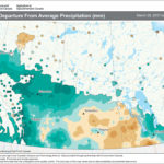
This map shows the total amount of precipitation as a departure from the long-term average for the 30-day period ending on April 27. Nearly all of Alberta saw above-average amounts during this period, with only a small pocket in the south and far north seeing below-average amounts. The driest region during this period was in south-central Saskatchewan along with western and extreme southern parts of Manitoba.

April didn’t bring much joy — and Alberta had the worst of it

Statistically, it wasn’t absolutely miserable but a dry stretch and a 
return to average temperatures would be most welcome this spring


Reading Time: 3 minutes Another month has come and gone, and depending on where you live it was either a near-average April or you were cold and wet. Listening to the general talk about April’s weather, you would probably come to the conclusion that most areas across the Prairies had a miserable month. But in reality, most places experienced […] Read more


This map shows pasture soil moisture levels as of the end of March compared to the long-term average. A large part of Alberta has near- to slightly above-average amounts of soil moisture. Parts of the Peace River and northern regions are going into the spring with well-above-average amounts.

Weather school is back in session — here are the basics of thunderstorms

How does solar energy result in thunderstorms? 
The answer lies with conduction, convection, and latent heat
Reading Time: 3 minutes With temperatures slowly starting to heat up across the Prairies, thoughts turn towards summer and summer weather, and in my case, I begin thinking about thunderstorms. After a very active summer last year, I thought it might be time to look at this topic again. I also thought it would be a good idea to take […] Read more

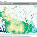
This map shows the total amount of precipitation that has fallen across the Prairies so far this winter (Nov. 1 to March 16). You can see that the wettest regions have been across southern Manitoba and into southeastern Saskatchewan along with extreme western Alberta. The driest regions were found north of Edmonton, southwards to east-central Alberta, and then eastwards towards Regina.

Springtime can be the ‘right time’ for really big snowstorms

When a buildup of warm, moist air from the south collides with 
cold arctic air, your snowblower can get a real workout
Reading Time: 3 minutes With spring officially here, the last thing most people want to hear about is snow. But the way this winter and spring have been going, who knows? Springtime across the Prairies tends to bring some of the biggest snowfalls of the year. Several years ago I dug into this topic, but I figured it was time […] Read more


This map shows the total amount of precipitation for Alberta during the three official winter months (December to February) as compared to average. You can see the northern region along with the Peace River region saw well-below-average amounts of precipitation during this period. Central and southern regions saw near-average amounts, with a few locations in the south receiving above-average amounts.


Warm weather wins out in this crazy up-and-down winter

The recipe was simple but unusual: Send in warm weather, 
then a big blast of cold, and repeat all winter long
Reading Time: 3 minutes From a climatological point of view, winter is now over. The 12-month year is broken into four equally long seasons, with winter covering December, January, and February. From a southern and central Alberta view, there is still one month to go. For most of the Canadian Prairies, winter starts in November and usually ends in March. In some […] Read more

This graphic shows the daily low (blue) and high (red) temperature during the last 12 months with the area between them shaded grey. It is superimposed over the corresponding averages (thick lines), and with percentile bands (inner band from 25th to 75th percentile, outer band from 10th to 90th percentile). The bar at the top of the graph is red where both the daily high and low are above average, blue where they are both below average, and white otherwise.

Doubt about global warming isn’t coming from scientists

It’s not hard to create doubt about sound science — 
the tobacco industry proved that years ago

Reading Time: 3 minutes Several years ago, Weather Underground’s co-founder Jeff Masters wrote a blog about the manufactured doubt industry, how and when it was created, and how it now plays into the current global warming or climate change controversy. At the time I emailed Masters asking permission to use some of the information from his blog in an […] Read more


This map shows the total amount of precipitation that fell across the Prairies during January. You can see it was a fairly dry month for most regions, with a large portion of Alberta, Saskatchewan, and western Manitoba seeing less than 60 per cent of average.

Articles on climate change provoke some readers

Like politics and religion, global warming is a polarizing topic —
but it’s one that we should discuss

Reading Time: 3 minutes Over the years, some of my weather articles have provoked or inspired various amounts of comments. What surprised me recently was the number of emails I received about the top weather events from around the world in 2016 — in particular, several from readers who accused me of leaning too heavily towards climate change or […] Read more

This map shows the total amount of precipitation that has fallen so far this winter (Nov. 1 to Jan. 15) compared to the long-term average. So far it has been a fairly dry winter across pretty much all regions of Alberta, with western areas being the wettest and northern and eastern regions the driest. Only a few locations west and northwest of Edmonton are above average, with much of the northern and Peace River regions reporting low to extremely low amounts.


The top global weather stories of 2016 had a common theme

Whether you look at temperatures, ice at the poles, air quality, or the 
Fort Mac fires, the evidence of a warming planet is clear


Reading Time: 3 minutes It seems that a new list of the top global weather stories of 2016 comes out every day. So I thought I would go through some of these lists and pick the top stories that are shared by all of the lists. Of course, I might have a slight bias towards Canadian stories. I don’t think […] Read more


This graphic shows the total number of severe summer weather events that took place across the Prairie provinces in 2016. A quick look at the graph shows that hail was the main severe weather event last summer. Manitoba led the way with 147 hail events and Alberta came in a close second with 144 events.

When it came to severe weather, Alberta (thankfully) was no. 2

We still had nearly twice as many ‘hail events’ as usual, 
but Manitoba was worse off for once

Reading Time: 3 minutes The new year comes with the usual list of Top 10 things about the previous year, and in the category of weather, this really appears to be the case. There are the Top 10 Prairie weather stories, Top 10 Canadian weather stories, and the Top 10 world weather stories (which often tend to be skewed […] Read more

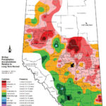
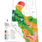
This map shows the total amount of precipitation that fell across agricultural Alberta during November compared to long-term averages.  Overall, it was a relatively dry month with most areas seeing moderately low to very low amounts of precipitation.  The one exception is the area between the central and northern region which saw average to moderately high amounts.

Let it snow, let it snow, let it snow, says our weather expert

Being snowed in at Christmas has many advantages, argues Daniel Bezte, 
but big Yuletide snowstorms are relatively rare

Reading Time: 3 minutes The holiday season is about traditions, and so it’s time once again to do my traditional look at Christmas weather across the Prairies. In particular, a look back to see what the warmest and coldest Christmases were, and if there have ever been big Christmas snowstorms. I’ve shared this with you before, but at this […] Read more