Forecast issued Dec. 31, covering Dec. 31, 2025 to Jan. 7, 2026
Highlights
- This forecast period is dominated by two lows — one to the far west, and one over Hudson Bay. The relative strength of the two lows will determine temperatures across the Prairies.
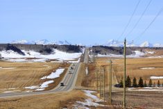
- Southern Alberta can expect mild temperatures.
- Saskatchewan and Manitoba will likely see seasonable temperatures with daytime highs in the negative teens and periodic disturbances with clouds and light snow.
Overview
It’s looking like we’ll soon see the active weather pattern, which has been in place for a couple of weeks, start to break down. That doesn’t mean we are done with weak disturbances.
Read Also

Farmers’ Almanac rescued from closure; fate of Canadian content unknown
The Farmers’ Almanac, which had said last fall it would cease publication at the end of 2025, will now continue under new ownership.
During the last forecast period, we saw several areas of low pressure track across the Prairies. While the forecast did a fairly good job predicting these systems, the timing, strength and exact track was a little off.
For this forecast period, we start with a large area of low pressure slowly retrograding over eastern Canada. This will eventually stall out over Hudson Bay. To the west, weather models are predicting a semi-stationary area of low pressure developing off the coast in the region of Washington, Oregon, and southern B.C.
More weather coverage: Predicting Manitoba winter snowfall
Between these two features, a northwesterly flow will cut from northwest Alberta southeastward into southern Manitoba. Areas to the north of this boundary will see below-average temperatures while regions to the south will experience near to above-average temperatures. The weather models are showing a few weak disturbances tracking along this flow, but at this point they do not look like they will bring much more than the odd flurry or a dusting of light snow.
What will be important during this forecast period is the strength of these two areas of low pressure. If the Hudson Bay low ends up stronger than currently forecast, temperatures across the Prairies will trend colder.
On the other hand, if the Hudson Bay low is weaker and the Pacific low becomes the dominant feature, the boundary between the cold and warm air will shift further north. This will allow milder air to spread across much of the Prairies.
Overall confidence in the big picture pattern is high, though confidence is a little lower when it comes to some of the finer details.
Alberta
This forecast period starts with fairly warm weather in place right across the province. Daytime highs range from around +5 °C in the south, near -5 °C over central regions, and close to -10 °C in the north. These mild temperatures look to stick around until Thursday before the upper ridge driving this warmth begins to collapse, allowing more seasonable temperatures to move in.
Along the top of this upper ridge, weather models are showing several weak disturbances pushing in from the Pacific Northwest into northern and central Alberta. These then dive southeastward across the Prairies.
These disturbances look to bring mostly cloudy skies to these regions with the chance of flurries and occasional periods of light snow. None of these systems appear particularly strong, with only the occasional centimetre or two of snow expected from any one system.
These disturbances are forecast to move through every day or two throughout the forecast period, so for some areas, total snowfall amounts could gradually add up. Temperatures during this time look to hover near average for late December, with daytime highs generally in the -8 to -12 °C range.
Across southern Alberta, temperatures look to remain fairly mild, with daytime highs in the 0 to -5 °C range for much of the forecast period.
Most of the precipitation looks to stay to the north, but a couple of weak lows are forecast to brush by. The first is expected around Sunday, with a second possible system around Tuesday. Neither low is expected to be particularly strong, with only a small chance of precipitation at this time.
Saskatchewan and Manitoba
Both Saskatchewan and Manitoba will be caught in the transition zone between colder air to the north and milder air to the south.
Several weak disturbances will slide southeastward in the northwesterly flow along this transition zone, with each bringing periods of cloud and the chance of flurries or occasional light snow. Snowfall amounts look to remain light — generally less than one or two centimetres with any given system.
More weather coverage: The year in review: heat, flood and fires
Temperatures look to be near seasonal for the most part, with daytime highs on most days ranging from -12 to -16 °C and overnight lows near -22 °C. Temperatures will be milder under cloud cover.
The warmest readings are expected over southern and southwestern Saskatchewan.
The main challenge with this forecast is the timing of the various disturbances, as weather models suggest one moving through every day or two. Another challenge is the exact track of these systems, which will depend heavily on the relative strengths of the Hudson Bay and Pacific lows.
All in all, it looks like 2026 is going to start off on a somewhat dull note, weather-wise.