It’s hard to believe, but we’re now in the last month of spring, and summer is just around the corner.
Just what kind of spring has it been across the Prairies? To answer that question, we’ll need to forget our feelings and impressions and take a look at the actual weather data.
The key information we’ll need to look at is temperature and precipitation, both actual and compared to average. As usual, I’ve selected main reporting centres for each of the three provinces, which are generally good representative samples for their respective geographic areas as a whole. The range I have selected is for the month of April.
Read Also

How Earth evens out the energy input
Earth has surpluses of radiation in its equatorial regions, and deficits toward its poles. Our weather is a matter of Earth trying to even out the imbalance, Daniel Bezte writes.


Looking at temperatures, you can see that in both actual temperature and difference from average, Alberta was the warmest location. It’s three stations were the top three in the chart.
Compared to average, Alberta was the only region that reported above average temperatures in April.
Regina and Winnipeg were in the middle of the pack, right around average for the month, with Saskatoon and Dauphin winding up as the cold spots coming in at 1.3 C below the long-term average for those locations.


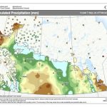
Looking at April’s precipitation you can quickly see it was once again a dry month across the Prairies with all the major reporting stations showing below average amounts. Calgary was the only location to report more than 20 mm of water equivalent precipitation. Precipitation across the rest of the Prairies ranged between eight and 15 mm.
Overall, it was a warmer than average April across Alberta, with Manitoba and Saskatchewan seeing near average temperatures. The northern agricultural parts of Saskatchewan and Manitoba reported below average temperatures. Precipitation was below average across all the major reporting stations in April.
Prairie summer forecasts
If we look back at the forecasts for the month, it appears that the CanSIPS model was the winner with its call of above average temperatures in April in Alberta and Saskatchewan, with Manitoba seeing below average temperatures. This model was the only one that forecasted below average precipitation. So much like last month’s winner, not perfect but someone has to win!
Now on to the latest and greatest seasonal forecasts covering the end of spring and summer.
The Old Farmers Almanac is calling for slightly above average temperatures in both May and June followed by near average temperatures in July and below average in August. Their precipitation forecast is calling for above average amounts in May, near average in June, and above average in July and August.
The Canadian Farmers Almanac, after reading between the lines, appears to be calling for average temperatures and above average precipitation in May followed by near to above average temperatures and precipitation in June. Their July forecast seems to be leaning towards a hot and dry month because they mention “hot and dry” a few times. The last month of the summer, according to them, will see near to above average temperatures with near average precipitation.
Moving on the different weather models. NOAA’s forecast looks to be calling for near average temperatures across the eastern Prairies in May and June which then transition to above average temperatures in July and August. The western Prairies are forecasted to see above average temperatures from May right through to August. NOAA’s precipitation forecast is for below average amounts in all four months.
Looking at the CFS model, it is calling for above average temperatures from May through to August. It also sees above average temperatures across Manitoba in May and also Alberta and the central Prairies in July. The precipitation forecast is for below average amounts in Manitoba in May with near average amounts elsewhere. June will see above average amounts in Alberta and near average amounts in Saskatchewan and Manitoba. July is predicted to be dry right across the Prairies, with August coming in around average.
Next up is last month’s winner, the CanSIPS model. This model is calling for well above average temperatures in May, with near to above average temperatures in June, July, and August. Their precipitation forecast is pretty straight forward, below average amounts for all four months.
Last on our list of computer models is the ECMWF which is also predicting above average temperatures and near to below average precipitation from May to August.
Here is my take on all of this. I do not remember the last time all the long-range models were pretty much in agreement. For the most part, all of them call for above average temperatures and below average precipitation, and I just can see going against them.
Let’s hope they are wrong, at least on the precipitation side of things.