I’ve had a couple of really good questions over the last few weeks. One was very timely about the Polar Vortex, and the other was a question about the impact of volcanic activity on our climate, particularly the Tonga volcanic eruption back in January of 2022.
Since the polar vortex question is a little more current, but no less important, I will cover that one first. I thought I might be able to cover both topics, but as I started to outline the volcanism and climate article, I realized that it would likely take a couple of articles to cover that topic properly, so I’ll leave it until early February.
If you have other topics you would like me to cover, please email me at: [email protected]. If I don’t reply back to you within a couple of days, send me a reminder email as sometimes an email can get buried, especially if it comes over the weekend.
Read Also
Weather whiplash: Alberta saw best and worst of winter this year
Prairie precipitation fell short of average this winter everywhere but Calgary, raising questions heading into seeding.
Now on to polar vortexes — what are they, how do they form, and why can they sometimes bring us such cold weather?
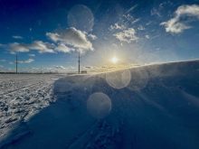
Well, maybe it is a little late for this topic as temperatures across the Prairies have rebounded from record- to near-record cold to the other extreme of record- to near-record warmth, but I still think a discussion of polar vortexes is relevant. The only real cold air outbreak we have seen this winter was thanks to the polar vortex.
I have discussed this topic in the past, once during the record-breaking cold weather winter of 2013-14, then again in 2018. I am sure there was a few more in between. So let us dig back into the archives and revisit just what the polar vortex is and how it can influence our weather.
A polar vortex is a large area of circulation (low pressure) in the upper atmosphere that is centered near both poles and tends to be the strongest in the winter. As the upper air cools, it contracts and loses height above Earth’s surface. This is what creates the area of low pressure in the upper atmosphere. It forms because the poles in the winter are not receiving any solar energy. The counterclockwise flow around this region in the Northern Hemisphere means that the atmosphere is flowing from west to east. The stronger the air flowing around the vortex, the more circular the vortex tends to be. If the flow weakens, the shape of the vortex tends to get distorted and we start to see large ridges and troughs form. Ridges are regions where the vortex has pulled northward, allowing warm air to move northwards, while troughs are areas where it sags southward, allowing cold arctic air to push south.
The polar vortex has been around, well, for as long as we’ve had the ability to measure the upper atmosphere. It’s likely that it has always been a part of the world’s overall weather patterns, so it is not a new thing. The term polar vortex has been used in the literature since at least the 1930s. This is what gets me going when I hear people talking about this feature as it being a new thing — it’s not.
So the question now is: are the cold temperatures we normally see in the winter always the result of the polar vortex? The answer is yes — and no. The polar vortex forms as a function of the cold temperatures that develop over our poles in the winter, and as I pointed out earlier, this is due to little to no solar input during this time of the year. The polar vortex, depending on the strength of the winds flowing around it, can create troughs and ridges that can allow cold air to surge southward. The polar vortex is not the only feature that can influence troughs and ridges, so we can’t always say that every cold snap is directly connected to the polar vortex, but for this year’s cold snap it was.
It’s a little like the weather version of ‘what came first, the chicken or the egg?’
This winter we are dealing with El Niño conditions across the equatorial Pacific, and this large-scale weather pattern can influence our weather. This leads us to the topic of teleconnections, which tries to describe how weather patterns upwind of an area tend to influence the weather over that area.
Our upwind area is the Pacific Ocean, so that is why we are always so interested in what is going on over the Ocean. El Niño, and its counterpart, La Niña, create a pattern of low and high pressure that can propagate eastward across North America.
So what does this have to do with our current shift from cold to warm weather? Well, it goes back to teleconnections. This pattern of low and high pressure over the Pacific has resulted in a large and persistent area of low pressure off of the west coast of North America. This in turn helps to develop an area of upper level high pressure to the east, or over the western Prairies. This upper ridge is what has been providing us with a predominantly warm and dry winter. So why/how did we end up with a short but fairly brutal cold snap? Well, the polar vortex can and does wobble around during the winter as the flow around the vortex strengthens and weakens.
As previously mentioned, a weakening in the flow can create troughs or dips in the vortex, so that it is not a nice circular feature, but rather an undulating rotation of cold air. Sometimes, if the conditions are just right, these wobbles or undulations can match up with a pressure pattern across the Prairies that allows for a part of the polar vortex to break off and drop southward.
This is exactly what happened with our mid-January cold snap. Part of the main polar vortex broke or split off and dropped into Western Canada. This feature stuck around for about a week before the prevail El Niño pressure pattern help to push it off to the northeast. In a more typical or non-El Niño winter, this cold snap would have likely stuck around for much longer.
What does this mean for the rest of February and March? Well, I will dive into that in more detail in the next article, but taking a quick look ahead it looks like the weather models are showing more warm air than cold air moving in.
As we draw closer and closer to the official end of winter it becomes rarer to see the polar vortex split and drop south, but as we have seen in the past (year) it is not unheard of. If the dry weather continues, and as we work are way into March, the sun continues to strengthen, and it won’t take much of a warm spell to quickly melt the snow.
This would then change the energy balance as the sun’s energy moves from melting snow to warming the air. This would then become just another factor trying to influence the overall weather pattern, often leading to warmer than average temperatures for that time of year.