The sun is shining, the birds are chirping, and there’s soon to be a buzz in the air — no, not the sweet sound of bees pollinating your crops, but drones.
And like pollinators, drones do their best work during the spring.
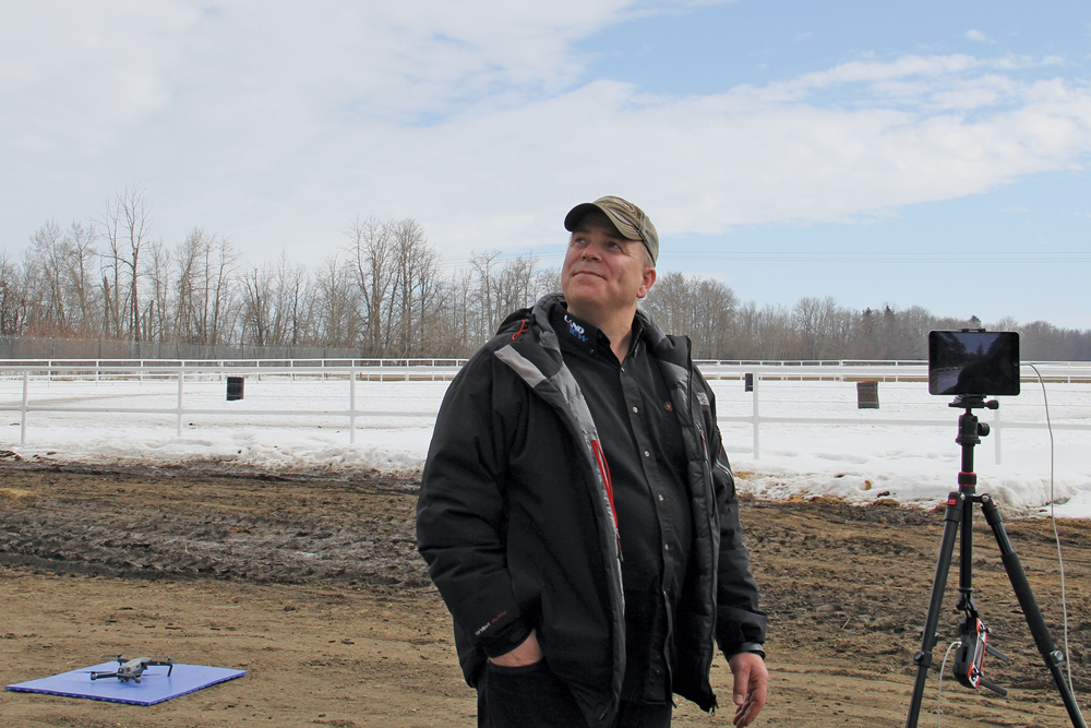
“Your drone isn’t just for taking pictures for your Twitter feed. It gives you important information,” said Markus Weber, owner of LandView Drones.
“It doesn’t take much to get real value out of a drone.”
While drones — or unmanned aerial vehicles (UAVs) — can give you a bird’s-eye view of your crop all through the growing season, farmers tend to see the most use out of their drones between seeding and flowering.
Read Also
Farming Smarter receives financial boost from Alberta government for potato research
Farming Smarter near Lethbridge got a boost to its research equipment, thanks to the Alberta government’s increase in funding for research associations.
In some cases, that means using your drone to double-check equipment before or during seeding to see how the soil is flowing over the shanks. And once you see emergence, you can use a drone to check emergence timing across the width of the drill to ensure your equipment is working properly.
“That doesn’t fix it for this season, but it will fix it for next season,” said Weber.
But post-emergence is when drones really start to take off.
That’s thanks, in part, to near-infrared sensors that show the normalized difference vegetation index (NDVI), a mechanism used to determine crop health and serve as a proxy for yield. Because healthy plants and unhealthy plants reflect light differently, the NDVI can show signs of plant stress before they’re visible to the naked eye — and the best time to do that is at flowering.
“The NDVI really changes once a crop flowers or heads out,” said Weber. “The yield proxy is actually highest during the vegetative stage of its growth rather than reproductive, and that’s why, for a lot of mapping, the NDVI is more useful early in the season when more things are flowering.”
Weed pressure is also most visible before the canopy closes, he added.
“Getting in early will give you an indication of where you have weeds, and that will help you later in the season.”
Drone pilot certificates
At this point in the growing season, though, farmers should be fine tuning their rusty piloting skills.
“One thing I’d suggest they do is get out and fly now that the weather is warm enough,” said Weber. “Just do a few sample flights now while you have time so that you can do two-minute flights later without having to practise then.”
That’s especially true for mapping.
“I encourage people to learn how to map with their drones at this point in the year, because that does take some learning and some practice,” said Weber.
“Get familiar with using something like Maps Made Easy or DroneDeploy that help you create a map, so that later in the season, you’ll know how to map your field effectively.”
But farmers don’t have to create a map every time they take their drone up.
“Just taking a quick look-see at 300 feet and snapping a few pictures is probably all they need to do in most cases,” he said. “They can scout a fairly large farm in one day and get a sense of what’s going on in their crops.”
Farmers should also be making sure they understand the rules around drone use — including a new requirement for pilot certificates. On June 1, every drone user will need to have a pilot’s certificate in order to fly a drone over 250 grams for any purpose, including recreational uses.
Formerly, a pilot’s certificate only applied to drones used for work or research or for ones weighing more than 35 kilograms. That rule will be extended to recreational users as well.
Basic pilot certificates (which are what almost all users will need) only require drone users to complete an online test. But more advanced operations (flying in controlled airspace, for instance) requires an online test and a flight review.
“Farmers who are preparing themselves for the season might want to go through that step now,” said Weber. “But a lot of people aren’t going to be ready for that this year, so there are professional pilots out there who would be able to fly for them.”
For those able to scout their own fields this summer, Weber’s advice is to “just get it up there.”
“Don’t overthink it. Just get your drone up and take a look at the crop,” he said. “That way, you’ll get to see more of the issues in your crop and find out problems you didn’t know you had before.
“It’s kind of like fishing. You’ve got to have your lure in the water to catch anything. It’s the same thing with drones.”
For more information about the regulations around safe drone usage or to access the drone pilot certificate test, visit the Transport Canada website.