Daniel Bezte has a special interest in farm weather, which he follows from a small farm near Winnipeg, where he has his own computerized weather station. He has been a regular contributor to other farm publications including the Farmers’ Independent Weekly and the Manitoba Co-operator. Daniel has a degree in geography, specializing in climatology, from the University of Winnipeg.
He welcomes questions and comments at [email protected]
Co-operator contributor
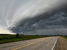
In our previous discussion about clouds we took a look at clouds with vertical development or cumulus clouds. Now we are going to move on to examine our high, middle and low cloud types.
Read Also

Thunderstorms and straight-line winds
Weather columnist Daniel Bezte discusses the strength of straight-line winds during a thunderstorm and the damage they can cause.
Starting at the top, let’s take a closer look at high clouds. These clouds, as we have learned, are known as cirrus, and that’s the name for the most common type. These are those high wispy clouds that often look like they have been stretched or blown out into long streamers – what is often referred to as “mares’ tails.” The reason for this appearance is that cirrus clouds are made up of tiny ice particles that are easily blown about by the strong upper level winds.
Cirrus clouds will generally travel in a west to east direction as they are blown along with the prevailing westerly winds. Generally, they are associated with fair weather, but they can also signal the approach of stormy weather. Cirrus clouds can be blown off the tops of thunderstorms and stretch out for several hundred kilometres ahead of the storm. Approaching areas of low pressure can also be preceded by cirrus clouds. In both cases, cirrus clouds slowly thicken and are replaced with lower clouds, so when this happens, there is a good chance that wet weather may be moving in.
Along with everyday cirrus clouds we also have cirrostratus clouds. These are high-level clouds that cover the whole sky like a sheet. These thin clouds are also made up of ice crystals and are usually thin enough that you can see the sun and moon through them. With these clouds we will often see halos around the sun and the moon. Since these clouds are a thicker form of cirrus clouds, the arrival of the cirrostratus clouds usually means a storm system is moving in – especially if they are followed by lower cloud types.
MIDDLE-LEVEL CLOUDS
Dropping down in the atmosphere we come to our middle-level clouds. Here we really only have two main cloud types: altostratus and altocumulus. We’ve already discussed the altocumulus clouds so let’s take a look at the altostratus clouds. This cloud type is gray or sometimes blue-gray and will usually cover the entire sky. With these clouds the sun or the moon can sometimes be dimly seen, but unlike cirrostratus clouds they will not produce a halo. Another way to determine if the clouds are altostratus or cirrostratus will be their colour, as cirrostratus tends to be white while altostratus will always be gray or blue-gray. Altostratus clouds are often found just ahead of storm systems, so seeing this type of cloud move in will usually be the precursor to some kind of precipitation event.
Finally let’s drop down to our low clouds or our status clouds. Stratus clouds, like the alto and cirrostratus clouds, will usually cover the entire sky with a uniform looking cloud. Stratus clouds tend to be a uniform gray colour and are often compared to fog that does not touch the ground. In fact, when fog rises and is no longer covering the ground, it becomes a layer of status clouds. Precipitation rarely falls out of stratus clouds, but we can see occasional drizzle with these cloud types. When status clouds thicken and become very heavy and wet looking, they are referred to as nimbostratus which simply means stratus clouds that are producing rain. These cloud types are associated with continuous precipitation whether it be rain or snow.
While these types of clouds can be hard to see due to the falling precipitation, the fact that precipitation is falling pretty much tips us off as to the cloud type. As for the type of weather associated with nimbostratus, well… rainy or snowy!
In our next issue we’ll wrap up our look at clouds by looking at some of the additional terms we can use to describe clouds and we’ll finish our cloud discussion by looking at some rare cloud types.