It’s been a rather remarkable spring across Alberta this year.
Looking back at the weather records for 2016 you could almost say that spring arrived in February, with temperatures running over 6° above long-term averages. Those mild temperatures continued into March, with mean temperatures that were around 5 degrees above average.
The big question after such a warm and early start to spring was: Would this warm weather continue into April and May?
So far, the answer is a resounding yes. April temperatures across all three main regions (Calgary, Edmonton and Peace River) were once again well above average for the month. Both the Edmonton and Peace River regions saw mean monthly temperatures that were in the 7.0 to 7.5 C range, which is about 3 degrees warmer than average. Around Calgary, the mean April temperature was about 9.0 C, which is about 4 degrees warmer than average. The month started off warm, with daytime highs in the mid- to upper teens across all regions, with even some low 20s reported. These warm daytime highs continued right through the month, with only a few days failing to make it into the teens for highs.
Read Also
Why is the sky blue?
The colour of the skies, on the Prairies and elsewhere, tells the story of the paths sunlight takes as it enters Earth’s atmosphere, Daniel Bezte writes.
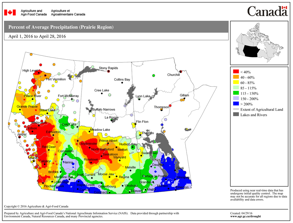
As it often happens, with the warm weather came dry conditions, at least in western and central regions. Both Calgary and Edmonton recorded very little precipitation during April. Calgary recorded only four millimetres, which is about 22 millimetres below average. Edmonton was only slightly wetter with about nine millimetres of precipitation, or about 20 millimetres below average.
Farther north it was a much wetter month. Peace River reported around 22 millimetres of precipitation in April, which is about five millimetres more than average. Most of the precipitation came from one event in the middle of the month when about 20 millimetres fell. It was much wetter over east-central and southeastern regions thanks to rain and wet snow that fell late in the month.
So the central and western parts of Alberta saw another warmer- and drier-than-average month with northern regions reporting a warmer- and slightly wetter-than-average April.
Looking back at the different predictions for April, it would appear that none of the long-range weather forecasts were correct. All of the forecasts called for near-average temperatures. On the precipitation side of things it wasn’t much better, with all the forecasters, except for one, calling for near-average amounts. The one outlier was the Canadian Farmers’ Almanac, which hinted that it might be a wetter-than-average month.
Now on to May and June’s forecast.
According to Environment Canada, it looks like warm weather will continue, with Alberta having a high probability of seeing above-average temperatures in both May and June. As for rainfall, it is calling for near-average amounts, with the south-central region having the best chance of seeing above-average amounts in both May and June.
The Old Farmer’s Almanac is calling for warmer-than-average temperatures in May along with below-average amounts of rain. This is then followed by a cooler-than-average June along with above-average amounts of rain. The Canadian Farmers’ Almanac appears to be calling for near- to above-average temperatures in May as it mentions pleasant and fair weather during the first half of the month and then some hot weather near the end of the month. Precipitation also looks like it will be near to above average as it mentions unsettled and thundery weather several times during the month. June’s forecast is a little tougher to figure out as it only mentions hot weather for a week in the middle of June, otherwise there is no mention of temperatures. So I am going to go with near- to above-average temperatures. For the precipitation forecast, I am going to go with near-average amounts as it mentions the chance for thunderstorms several times during the month.
Last but not least, my forecast.
I am calling for above-average temperatures in May along with below-average amounts of rain. Current mid-range weather models are showing fairly warm and dry conditions dominating our weather right through to the third week of May. It looks like the current weather pattern will continue, which means the warm/hot weather will also continue into June.
In fact, some long-range weather models are hinting at the possibility of an extremely hot summer over a large part of central North America. But as usual, we’ll have to wait and see just what Mother Nature has in store for us.