Looking back at the last few months, we saw July come in with below-average temperatures after a prediction of above-average values.
Then August came and went, and when all was said and done, that month came in with near- to slightly above-average temperatures.
So, what did September bring? Well, unless you never went outside, you probably know that is was a warmer than average month. The question is, ‘Just how warm was it?’
Read Also
Southern Prairies brace for dry spring after below-normal winter
A dry winter across southern Alberta and Saskatchewan raises crop concerns for 2026, while northern regions benefit from above-average snow.
Temperature
As usual, we will look at the average temperature rankings for the main reporting centers in each province, followed by a look at how those actual temperatures compare to average. We will follow that up with a look at precipitation rankings and how they compare to average. Then we will jump into the long-range outlooks and see if there have been any changes to the thinking of the weather models.
Looking at the mean monthly temperatures for the month of September, the warmest actual location was once again Winnipeg, coming in at 15.8 Celsius. This was followed closely by Regina at 15.9 C and then Calgary at 15.6 C.
Comparing the mean monthly temperature to average, the warmest locations were Calgary, coming in 4.6 C above average, with Regina coming in second with 4.1 C warmer than average, and Edmonton a close third at 4.0 C warmer than average.
The cold spot was Peace River, with a reading of 13.4 C, which is not unexpected at this time of the year due to this region more northerly location. The coldest region compared to average was Brandon, coming in at a measly 3.2 C above average – which in all seriousness is still pretty darn warm.
This September was very reminiscent of last September when temperatures averaged from 2.6 to 5.6 C warmer than average.
Looking back at the last 15 years of data, I found that 10 of those years saw warmer-than-average Septembers and three were near-average, which means only two reported below-average temperatures. It is looking more and more likely that this may be our new normal, heading into fall.
Precipitation
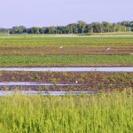
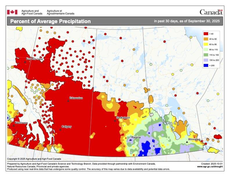
Looking at precipitation, it was extremely dry across the western half of the Prairies, with most of Alberta seeing little-to-no precipitation during September. Precipitation was near-to-above average across southern Manitoba and parts of southern and eastern Saskatchewan, while central regions of Saskatchewan saw below-average amounts.
Turning to temperature, overall it was a much warmer-than-average September, with western regions seeing well below-average precipitation, and eastern regions seeing near- to above-average amounts.
Looking back at the forecasts, the winner would have to be the CFS model with its forecast of well-above-average temperatures and below-average precipitation.
Forecasts
Now on to our look at the latest medium-to-long range forecasts. As usual we will start off with the almanacs. The Old Farmer’s Almanac is calling for near- to slightly above-average temperatures and precipitation during the last couple of months of fall and into the first month of winter.
The Canadian Farmers’ Almanac appears to be calling for below-average temperatures in October and November along with above-average precipitation. It then looks like to transition to near-average temperatures and precipitation in December.
Moving on now to the different weather models. Last month’s winner, the CFS model, is calling for above-average temperatures in October and November with near-average temperatures across the eastern Prairies in December and western regions seeing below-average temperatures. Precipitation will be below-average in October with near-average in November and December.
The CanSIPS model calls for well-above-average temperatures in October which then transitions to near-average in October and below-average in December. Their precipitation forecast is calling for near- to below-average across all three months
Looking at NOAA’s prediction — and, as usual, extrapolating northward, as its model just disappears at the Canadian border — it appears to call for the next three months to see near-average temperatures and precipitation, except for southern Alberta seeing above-average precipitation.
Last is the ECMWF or European model. It calls for above-average temperatures in October and November, transitioning to near-average in December. Their precipitation forecast is calling for below-average amounts in October, transitioning to above-average by December.
Now on to my two cents. There are no strong forcing mechanisms in place that look to push us into a colder-than-average pattern. So, I am going with a warmer-than-average October and first half of November with temperatures then cooling to near- or even slightly below-average by early December. Precipitation, always difficult to predict, will be near-average in October, transitioning to near- to above-average by mid-November and into December with the western Pairies seeing a good chance of below-average precipitation throughout this period.